Peaceful Gila Skies
Stop Expansion of Military Pilot Training Above the Gila Wilderness
Air Force Proposes to Create Low-Level Supersonic Airspace Across Southeast Arizona/Southwest New Mexico
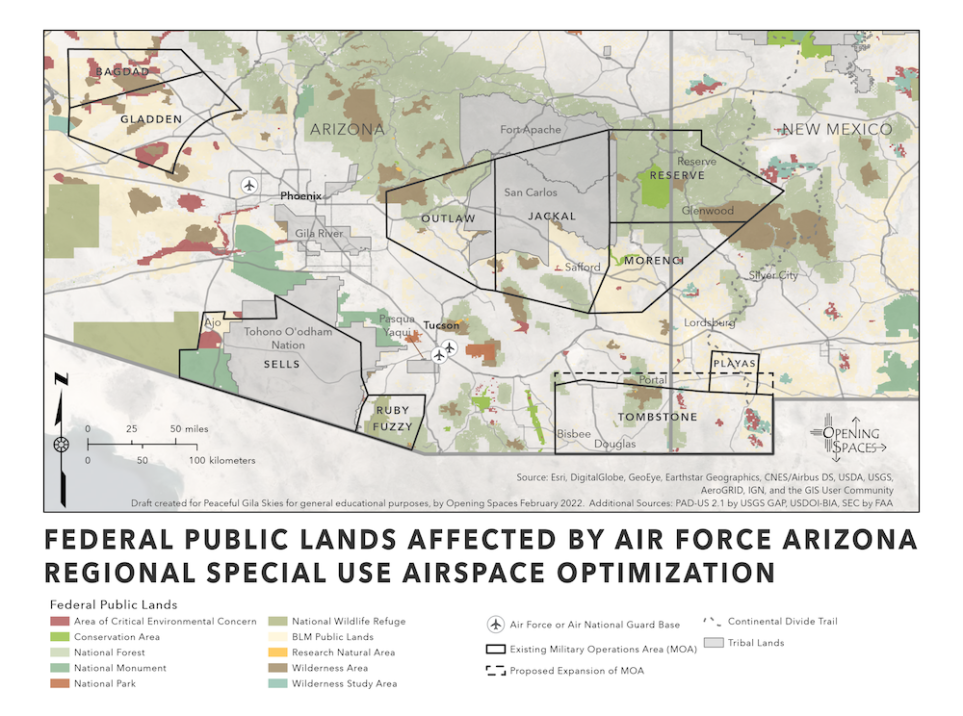
The Federal Aviation Administration is now accepting public comments on the Air Force’s proposal to expand military combat training across southern Arizona and southwest New Mexico, including over the Gila Wilderness and tribal lands. The FAA will have a role in the final decision on this airspace expansion. Comments are due September 19, 2025.
The proposal would authorize thousands of additional low-elevation fighter jet maneuvers, supersonic flights as low as 5,000 feet, subsonic flights to 100 feet, and the dropping of flammable flares. Peaceful Gila Skies is preparing detailed comments and will share specific issues for public comment in early September.
Pilots and aviation professionals: If you would like to provide public comments or need more information about the aviation impacts, please contact us at peacefulgilaskies@gmail.com.
The U.S. Air Force wants to modify 10 existing Military Operations Areas (MOAs) that stretch across southern Arizona into southwest New Mexico as part of a plan for expansion of Special Use Airspace in the southwest region of the country. The Draft Environmental Impact Statement (DEIS) plan will authorize low-level fighter jet maneuvers and supersonic flights that cause sonic booms above rural and tribal communities, some of the Southwest’s most fragile sky-island ecosystems, and beloved wilderness areas and national monuments.
